
One of the more flexible hikes – it can be easy and quick, or looong depending on your preference. It’s one of the hundred famous mountains, and for whatever reason I have not have heard of it, which is a pity because the ridge is simply beautiful and peaceful.
Budget: JPY5,420 (~USD51)
- JPY1,690. Train from Nakano Station to Kai-Yamato Station.
- JPY1,020. Bus from Kai-Yamato Station to trailhead
- *multiplied by two for the return trip
- *We actually rented a car, and ended up paying JPY4,500 per person so it may be a better alternative
Hike Date / Difficulty (Elevation: 2057m /6749ft.)
- June 6, 2020.
- 2 out of 5 for me. It very quick easy but can be easily adjusted to make it a bit longer.
- Route below is around 8.3km, with an elevation elevation change of ▲770m/ ▽773m (3h45m map time)
- Map Link
When to GoAny time during the year, but some blogs say it sees snow in winter, so bring spikes then.
Special Notes- Weather check : Japanese
- There’s an emergency hut in the middle of the ridge, but there is no door so winter might be a bit risky.
- The road to the trailhead is a winding road. I actually got a bit carsick.
- Can be a dayhike or an overnight hike, as there are numerous starting points and trails.
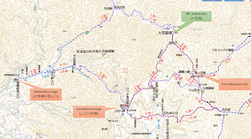
- Trailheads. There are a couple of starting points, and your transportation will depend on such:
- Kamihikawa-touge (上日川峠線). This is a much closer starting point to the summit, and you have about 45 minutes to an hour to the summit.
- The bus is from Kai-Yamato Station (甲斐大和駅) (JPY1,020 one way, last train heading home at 15:45). Bus schedule here, look for "大菩薩上日川峠線". As a rule, bus runs from third week of April to second week of December.
- Daibosatsu-touge (大菩薩峠登山口).
- This will add at least two hours to your time going up, and the bus leaves from Enzan Station (塩山駅). (JPY300 one way, last train heading home at 18:00). Bus schedule here, look for "塩山駅 ⇒ 大菩薩の湯 ~ 大菩薩峠登山口 ~ 柳沢峠 ~ 落合". It seems that the bus runs throughout the year, except for Dec 31 to Jan 3.
ItinerarySaturday (Using Kai-Yamato Station as starting point)
- 06:22 – 08:03. Train from Nakano Station to Kai-Yamato Station.
- 08:10 – 08:51. Bus from Kai-Yamato Station (甲斐大和駅) to Kamihikawatouge (上日川峠)
- 09:00 – Start hike
- 14:00 – End hike
 |
The start of the hike was a nice lush green.
|
 |
This was close to the summit. We were only a little bit over an hour in, and this is the peek of the view waiting for us.
|
 |
| Yey! The weather forecast was pretty bad, so I'm thankful we had a view. While celebrating our little hike, we realized this is NOT the summit. It is a little segue opposite the pile of rocks. |
 |
Summit! We had our lunch stop here, even though there's zero view haha.
|
 |
| When we went back to the fork, the clouds have settled in and blocked our views. We continued on to the loop, which is behind the rocks to our left. |
 |
And soon enough we saw the view that generally is used to represent Mt. Daibosats.
|
 |
Walking across that ridge.
|
 |
There were some ups and downs, but nothing beyond beginner level.
|
 |
Mountain hut! It's free, but does not have a door so that might be a problem in winter.
|
 |
Here's the trail to the mountain hut.
|
 |
Soon enough the vegetation changed.
|
 |
| The rest was basically like this. |
 |
Probably the steepest section of the hike.
|
 |
This might be my favorite view for the entire hike.
|
 |
| The rest of the hike back was a couple of hours like this. And when you think it's over, there's still some more haha. We had to go past a couple of little streams. One guy in our group went off trail for a bit to take a soak too. |


Comments
Post a Comment
Comments are like mail in my postbox. Such a nice surprise. ^__^