Mizugaki is an underrated mountain, and is now one of my favorites. It's a chill hike that has chains, ropes, river crossing (hop on rocks!), Mt. Fuji view, rock scrambles, and in our hike - black ice, frost, peak autumn colors and perfect weather.
Budget: JPY4,500 (~USD43)
- JPY4,500. Share in car expenses.
- October 30, 2021
- Difficulty: 3 out of 5
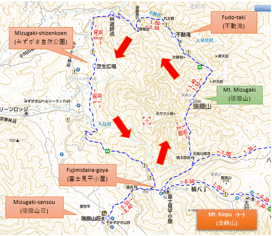
- Route from Mizugaki-sanso:
- backtrail: around 5.2kilometers, with an elevation change of ▲977m/ ▽977m; 5h00m
- loop: around 10kilometers, with an elevation change of ▲1,315m/ ▽1,303m; 7h17m.
- Map Link
When to Go
Buses are only running from April to November, so that's the official hiking season.
Buses are only running from April to November, so that's the official hiking season.
Don't know how it is in winter as I haven't checked, so leave a comment if you stumbled on this blog and need me to check.
Special Notes
Itinerary
**via car, with the starting point at Mizugaki-shizenkoen parking lot**
Special Notes
- Weather check: English / Japanese
- Highly recommended that you do this with Mt. Kinpu (金峰山). Here's the itinerary.
- This hike has rope and chain sections. Nothing extreme, but care is needed. I would recommend doing the loop counterclockwise. One is due to the nature of the trail, and another is due to the likely human traffic if you backtrail.
- The trail from Fujimidaira to the summit is mainly big rocks that requires the use of hands, so bring gloves.
- The trail from Fudotaki to the summit has a few rope/chain sections, but mainly stairs/roots/soil. Between Mizugaki-shizenkoen and Fudotaki are some river crossings, most of which have bridges.
- Signs throughout the mountain are interchanged between 瑞牆山 and みずがき山.
- Trailheads: Just Mizugaki-sanso (みずがき山荘).
- Train, Tokyo to Nirasaki Station (~JPY2,500 one way)
- Bus, Nirasaki Station to Mizugaki-sanso (JPY2,060, 1h12m one way)
- If with car, there are some parking lots closer to the trailhead, which can save you an hour or two of hiking. Check the P signs on the map above.
- Mountain huts.
- Paid.
- Fujimidaira-goya (富士見平小屋). Contrary to expectations, I did NOT see Mt. Fuji when I passed here. Maybe I just don't know where to look.
- Free. None.
- Camping.
- Fujimidaira-goya (富士見平小屋)
- Mizugaki-shizenkouen parking lot.
Itinerary
**via car, with the starting point at Mizugaki-shizenkoen parking lot**
Itinerary for using public transportation is in the comments.
- 04:00am. Start driving to the parking lot.
- 08:00am. Arrive at parking lot. Start hike.
- 12:00pm. Arrive at summit.
- 02:30pm. Back at the parking lot.
Actual log
- 04:30am. Started driving.
- 07:03am. Arrived at parking lot. Started hike.
- 08:38am. Arrived at Fujimidaira. Had our breakfast break.
- 08:53am. Started the hike again. It was a short ascent, then flat section, then a steep descent to approach the main climb to Mizugaki.
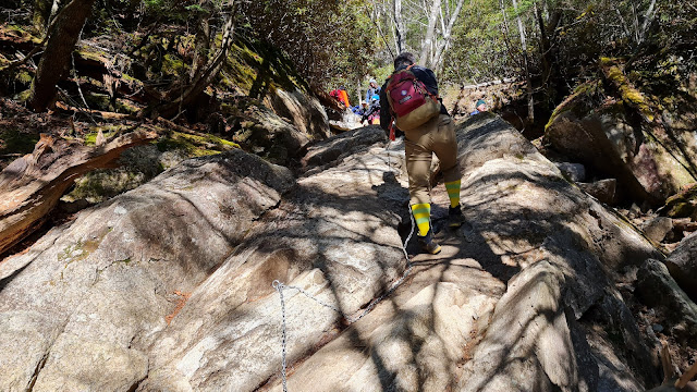
- 09:18am. The main climb starts, and it was a lot of hands and chains and so much fun! But since there are a lot of chain sections, there is a lot of bottleneck too.
- 10:47am. Arrived at summit. It was a very crowded and scary (cliffs!) summit. It has an unobstructed view of Mt. Fuji and the surrounding southern alps, which is just gorgeous.
- 11:56am. Started our descent. From here on, we followed the signs to Fudotaki (不動滝)
- 01:36pm. Arrived at Fudotaki.
- 03:18pm. Back at the parking lot!!! Yey!
 |
| The parking lot. At around 7am, the entire thing is maybe halfway full. |
 |
| Starting the hike. The trail is behind the toilet. |
 |
| Going up the stairs next to the toilet. |
 |
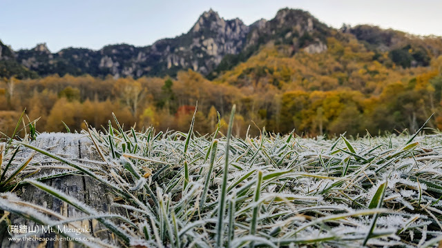
| It was a gorgeous view that morning, with the frost covering the grass. |
 |
| The trails is in this roped off section. Just hop over that. |
 |
| Also need to hop over this. Honestly, if others were not there ahead of us, I would think this is NOT the trailhead. |
 |
| The official trail right behind that rope. |
 |
| Yey autumn! |
 |
| It was mainly flat. |
 |
| A quick bridge. |
 |
| Be alert and check your map - the trailhead to Fujimidaira (富士見平) is a turn off the main trail. |
 |
| Continuing on. This was such a gorgeous, gorgeous hike. |
 |
| Arrived at the road. Turned left. |
 |
| Followed the main road. |
 |
| The watering hole right below Fujimidaira. |
 |
| Plenty of water. |
 |
| Fujimidaira! |
 |
| Plenty of campers. |
 |
| The toilet. It is a mountain toilet that is smelly and has no flush. And it costs JPY100 per use. |
 |
| The sign for the split of the trail to Mizugaki and Kinpu. To the left is Mizugaki, but the sign is half broken. |
 |
| One small clearing where we saw the Mizugaki rocks. |
 |
| Relatively flat trail. |
 |
| A segue if you want an extra summit. |
 |
| Then we had to descend quite a bit. |
 |
| A big rock! From here on, the attack to the summit starts! |
 |
| Chain section! |
 |
| Some gullys. |
 |
| Some sections have stairs/ladders. |
 |
| Oh! Summit! Just 5 minutes left! (spoiler alert - no, that's not the summit, and no, it was NOT five minutes away) |
 |
| Another chain section. I love chain sections, except when there are cliffs. In this case, no cliffs throughout the hike. |
 |
| A short chain section. |
 |
| Saw a dead bat. I didn't dare touch it. Heck, we are not done with the current pandemic I don't want to start another. |
 |
| The last chain section!. Ok, this one I really didn't like because the left side which is more doable is covered in black ice. So only the right one can be used and it was a pretty big step with no footholds. |
 |
| Continuing with our rock scramble. |
 |
| Ok, I think this time I'm really almost there. |
 |
| Ok, maybe just one more ladder. |
 |
| WHOA! Yey Fuji! |
 |
| The summit marker. |
 |
| Shot from my drone - see how crowded the summit is? |
 |
| My drone with Mt. Fuji! |
 |
| On our way down. We backtrailed to the fork, and from here on followed the signs to 不動滝 |
 |
| The rooty way down. |
 |
| This looked a lot better in person haha. |
 |
| A really strong stick. |
 |
| Gorgeous trails covered in moss. |
 |
| Finally some benches. |
 |
| Here's 不動滝. Yeah, it was a disappointment. |
 |
| Continuing with the descent. |
 |
| One of the river crossings without a bridge. |
 |
| Again, it looks so much better in person. Please believe me. |
 |
| Almost done! We are back to the autumn foliage. |
 |
| Just gorgeous! |
 |
| Arrived at the fork, turned left. This time it doesn't say みずがき自然公園, but just look for 公園. It's the same place. |
 |
| Continuing on. |
 |
| WHOA. A golf course will be envious of this trail. |
 |
| Back at the parking lot. I CANNOT ask for a better weather. |
 |
| The almost full parking lot in the afternoon. |
**via Public Transport**
ReplyDeleteBudget: JPY9,140 (~98USD)
-JPY2,510. Train, Nakano Station to Nirasaki Station.
-JPY2,060. Bus, Nirasaki Station to Mizugaki-sansou.
-JPY2,060. Bus, Mizugaki-sansou to Nirasaki Station.
-JPY2,510. Train, Nirasaki Station to Nakano Station.
Route below is around 10kilometers, with an elevation change of ▲1,315m/ ▽1,303m; 7h17m. (loop)
Itinerary
-05:50am. Train from Nakano Station at Nirasaki Station. Transfer at 6:29am at Hachioji Station, JPY2,510. If you are willing to pay JPY4,220, you can take the express train and arrive at 08:36am.
-08:28am. Arrival at Nirasaki Station.
-08:50am. Take the bus at Nirasaki Station to Mizugaki-sansou.
-10:02am. Arrival at Mizugaki-sansou. Start hike.
-10:50am. ETA: camp area, Fujimidaira-goya (富士見平小屋).
-12:50pm. ETA: Mt. Mizugaki (瑞牆山) Summit.
-03:20pm. ETA: Camp area.
-04:00pm. ETA: Mizugaki-sansou bus stop.
-04:30pm. Bus to Nirasaki Station.
Mt. Mizugaki is great, isn't it?
ReplyDeleteYou have a nice blog, by the way!