Famed as "the most difficult hyakumeizan 日本百名山中最難関", you'll have to cross a couple of mountains in a bear country to reach Mt. Poroshiri.
But more than half of the hike is a walk across the ridge where the sheer size of the mountains surrounding you will make you feel so small. Looking back at the pictures, it's one of the most beautiful hikes there is in Japan, and worth all the effort to get to.
I don't know which was harder - the logistics or the 19 hr dayhike. I think the logistics took me WAY more than 19 hours. Haha.
Budget: JPY5,600 (~USD45) from Obihiro
JPY5,600. Share in car rental (36hrs) and gas, divided by 3 people.
I have done this with other Hokkaido hikes, so please refer to this post for the actual costs.
Hike Date / Difficulty (Elevation: 2,052m / 6,736ft)
July 13, 2022. Yes, just one day. We started driving at 12 midnight, and was back around 11pm.
Difficulty: 5 out of 5
Route below (via Chiroro-gawa trialhead) is around 25.4kilometers, with an elevation change of ▲2,623m/ ▽2,623m (18h20m)
Also called "日高幌尻岳", as it is nestled in the Hidaka (日高) Mountain Range.
Notes from my hike (via Chiroro-gawa trailhead)
TICKS! This mountain has ticks. How do I know? I was bitten by one. I had two underneath my long sleeves shirt, and one bit me. I noticed them in the shower, quickly pulled it off (ouch!), went to the doctor the next day who only checked that the head did not remain. Cost me JPY1,280 with insurance.
The trails are clear and easy to see, but not well used nor maintained. The bushes were overgrown and quite painful as the push into you. Definitely recommended to wear long sleeved shirts and pants.
River crossings from Ninozawa Deai, for maybe an hour? The rivers can get swollen, so do NOT hike when raining, or be prepared for soaked shoes. Nothing too sketchy when we did our hike, but a raging river is always high risk.
Since we did a dayhike and it took us 19hrs, we needed at least 3 liters of water per person. There is a water source though, but someone told us that water in Hokkaido is not as safe because of the Hokkaido wildlife. So we decided to not partake in any of the water on the trail.
Mountain Huts
For an overnight hike, the only choice is Poroshiri Sansou. If you have 3d2n hike, then Niikappu Poroshiri Sansou is an option.
Paid/Free-ish
Toyonuka-sansou (とよぬか山荘, google maps pin). Not really at the mountain, but close to the trailhead. . JPY3,000, no meals, though the meal seems decent for an additional JPY2,000 (dinner and breakfast).
Niikappu Poroshiri Sansou (新冠ポロシリ山荘). JPY1,000 a night, reservations via email.
Poroshiri Sansou (幌尻山荘). Open throughout the year but not accessible as the trailhead is not accessible outside of the official hiking season.
Also closed for cleaning around first Saturday of August
With a minimal fee of JPY2,000 per person per night, but this has to be paid via bank transfer two weeks in advance. The reservations for the hut starts December 15 the prior year. Starting 2022, it seems that reservations can be made online, though payments still via bank transfer. .
Bank details, via JP Post
Account Name: 平取町山岳会
Account Number: 二七九(ニナナキュウ)店 当座0055508
Camping.
via Chiroro-gawa trailhead.
Ninozawa deai. An official camp spot about 2 hours away from the trailhead.
北戸蔦別岳 summit. Not an official camp spot, but I saw at least three tents wild camping here. It's a stretch as there is barely any flat spot, but I think this is the best halfway point to camp in. There are a couple of flat spots close to this summit too, but after, not so much. I think that トッタベシ岳 (戸蔦別岳) should also be OK for wild camping, but I didn't see anyone camp here.
Trailheads.
I'm going to write down the two main ones here.
Rindou Dai 2 Gate (林道第2ゲート). Main trail, and private cars can only go up to Toyonuka-sansou.
Step 1. Travel to Toyonuka Sansou.
Flight, Tokyo to Sapporo's New Chitose Airport.
Train, New Chitose Airport to Tomikawa Station (富川駅), about 2 hours one way.
Fare ranges from JPY1,700 (depart at 7:02am), or somewhere between JPY2,230 (depart at 11:30am, 1:30pm, etc) or JPY3,390 (depart at 11:06am, 4:30pm, etc)
Bus, Tomikawa Station (富川駅) to Furenai (振内案内所, google maps pin). There are two buses in a day, 09:26am and 6:21pm. JPY1,330, 54 minutes one way. Google maps work well, so just use google maps using this google maps pin
Taxi, Furenai (振内) to Toyonuka-sansou (とよぬか山荘). Around JPY3,500 for a 3 person taxi, or JPY5,000 for a 4-9 person car (estimates here, 16 minutes, 12.1kms). Call 01457-3-3021 for reservations (required). If coming from Tomikawa Station (富川駅), it'll be JPY18,000 for 4-9 people, JPY36,000 if from the airport.
Step 2. Shuttle, Toyonuka-sansou (とよぬか山荘) to trailhead, Gate 2 (林道第2ゲート)
JPY2,000, one hour, 21.6kms one way. Call 01457-3-3838 for reservations (required).
Chiroro-gawa Dai 2 Gate (チロロ川第二ゲート). Google maps pin. Google maps does NOT recognize the rough road section as a road for cars, so for car navigation, I inputted this location. From here on, you can use the trailhead's pin, but use the "walk" option.
This is the only trailhead where it is doable as a dayhike, which is a 17.5-20 hour hike. So maybe not a dayhike. Haha.
Double check access, as it seems the road is closed outside of hiking season. It's about 93 kms from Obihiro Station (where we rented the car). Road status is here.
For our 2022 hike, normal cars can come in from May 14, 2022.
There is a long 10km rough road of driving getting to this trailhead, and a parking lot that can accommodate about 5 cars I think. Be careful driving here, as I was told this messed up our car rental (rocks hit the bottom of the car).
After parking, the first 1.5hrs of the "hike" was just a rough road to the camping spot. We had to pass 9 bridges, not river crossings, just bridges. We counted coz I was upset with how far the parking lot was after 18 hrs of hiking!
The first section of the hike was the rough road, then river crossings, then a steep ascent up a muddy trail to the ridge. Once we reached the ridge, it was almost an all-ridge walk to the summit.
Itinerary - via Rindou Dai 2 Gate (林道第2ゲート).
Friday
Fly into Sapporo, try to stay around Tomikawa Station. If not possible (as the last bus is around 4:30pm), then just stay in Sapporo or Chitose area.
Saturday
10:20am. ETA: Furenai (振内案内所). Given there's only one bus in the morning, this is the only possible arrival time.
10:20am. Taxi, Furenai (振内案内所) to Toyonuka-sansou (とよぬか山荘)
10:36am. ETA: Toyonuka-sansou (とよぬか山荘)
10:40am. Shuttle, Toyonuka-sansou (とよぬか山荘) to trailhead.
11:40am. ETA: Trailhead. Estimated total time from trailhead to mountain hut is 280 minutes.
05:00pm. ETA: Poroshiri-sansou (mountain hut). Rest for the day.
Sunday
Estimated total time from mountain hut back to trailhead at 660 minutes. Adjust the estimates depending on the actual speed vs map time
04:00am. Start hike.
12:00pm. Target shuttle, return trip.
Actual Log- via Chiroro-gawa Dai 2 Gate (チロロ川第二ゲート)
I did this hike a couple more Hokkaido hikes, and was staying at Obihiro after doing some Kushiro hikes. We were not able to reserve a hut, and was not comfortable wild camping in a bear country. About three days before our hike, the logs showed bear sightings at our chosen trail.
12:00am. Starting driving to trailhead. We drove past a small town first, and after that it was just road. No convenience stores. So prepare food way in advance. On our drive, we saw a fox and a deer on the road (near the rough road section).
02:30am. Arrived at the trailhead and started our hike. There were two cars in the parking lot when we got there.
05:10am. Finished the river crossing section of the hike, and started our ascent up the ridge. We passed by a water source too, the sole water source in the entire hike.
07:09am. Reached the ridge. Took some snacks and lots of pictures, and continued on.
08:02am. Reached 北戸蔦別岳. Took a 15 minute break, and stashed some of our stuff here. I left my 2L bottle here, and that will be my drink for the descent.
09:34am. Reached トッタベシ岳 (戸蔦別岳), Took some quick pics, and the started the steep descent. Then we had to cross... I don't know what it's called but it looks like a ridge and it's absolutely gorgeous, and we had to cross that to reach the base of Poroshiri. Then we had to go all the way up again, and thought it was the summit, but NO! The summit was almost an hour away still.
11:49am. Reached the summit!
12:11pm. Started our descent.
02:27pm. Reachedトッタベシ岳 again.
03:47pm. Reached 北戸蔦別岳. Took our drinks, and headed back down.
08:58pm. BACK AT THE PARKING LOT! We immediately started driving back home.
11:20pm. Back at our hostel.
Driving to the trailhead.
We encountered a deer!
The rough road section.
Our hike starts! We had to pass this gate (entry at the side)
Some portions of the rough road (for hiking) was muddy.
Trail right next to a river. Not going to be fun if it's raining.
The sun has started rising and we were treated to a bit of a pink sky. Not much visibility though.
Very forest-y trail.
Back to the river.
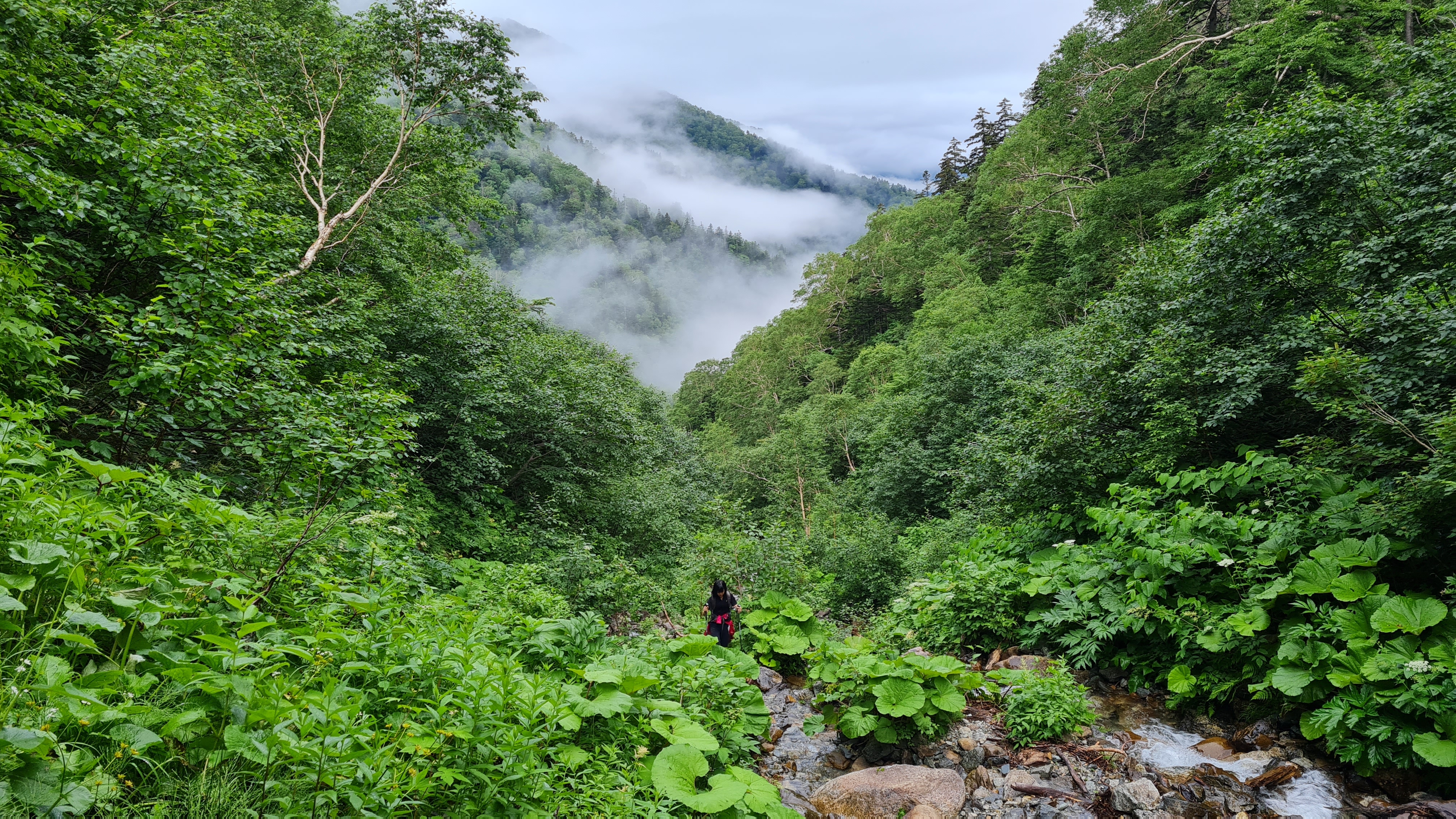
Plenty of river crossings.
Going up the river.... You could see the pink ribbon above - so yes, this is the trail.
Looking back down.
No, we did not go up this waterfall. This is the section where we left the river and did a steep ascent to the ridge.
Pretty steep ascent.
And muddy.
The water source on the trail.
Almost there!
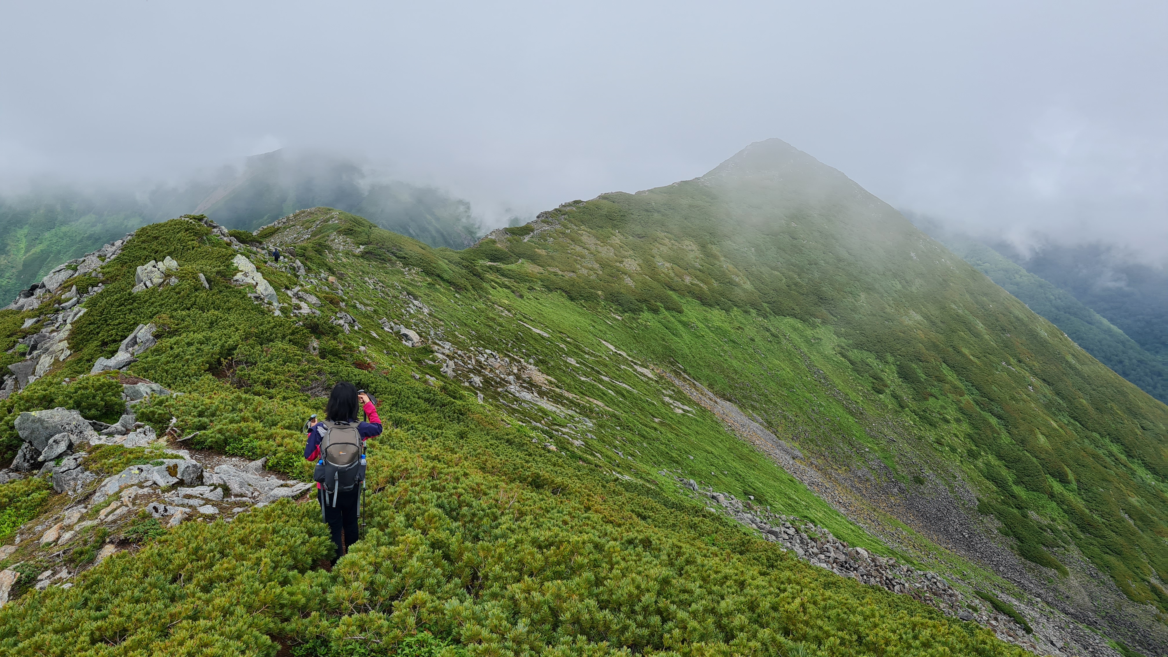
The ridge! From here on, it is all ridge walk with the most gorgeous views (if you are lucky with the weather).
Uhm, is this a marker?
Yeah, a marker.
Oh well, continuing on.
Some flat section for those who wish to wild camp.
Beautiful flowers! Yes, not good weather.
The clouds does have a nice feel to it though.
Beautiful even without the views.
The summit that should be the best viewing point of Poroshiri. As you can see... we could not appreciate the view as much.
Doing a rather steep descent.
The clouds started lifting.
WHOA. POROSHIRI!!!!! I rushed and rushed and rushed so I can summit while the weather was good. Apparently the summit was still a couple of hours away. >.<
At 12 noon, we reached the summit.
Bye summit! Unfortunately the clouds were back at it again.
Crossing the ridge to the big drop.
With the clouds clearing up for a second.
Is that bear poop?
WHOAAAAAA.
Our friend practically falling asleep waiting for us.
Going across the ridge on our way back.
Some people were wild camping.
Another wild camper.
Continuing on with our descent. The clouds have cleared a bit, and we were treated to the beautiful views of the hike we did in the morning.
Right before the big descent down. Almost done at this point, just five more hours to go!
BUDGET : JPY12,340 (~USD118) from Sapporo - JPY2,840. Bus, Shin-chitose Airport < > Tomikawa Station (JPY1,420 one way) - JPY3,500. Taxi, Tomikawa Station < > Toyonuka-sansou (JPY3,500 one way, assumed to be shared between 2 people) - JPY4,000. Shuttle, Toyonuka-sansou (とよぬか山荘) to trailhead, Gate 2 (第2ゲート) (JPY2,000 one way) - JPY2,000. Mountain hut.
Thanks so much for organising all of this awesome information! One question, do you think it's necessary to get water shoes for crossing all the rivers?
There were enough rocks for the river crossings that waterproof shoes + gaiters might be enough. At least when we hiked (even after some rainy days), there was no place where we had to wade through the river. Highest was maybe five inches?. Of course, that can easily change with stronger rain.
I was wearing mid high waterproof shoes and I was lucky to have almost dry shoes throughout. Another got her waterproof shoes soaked and hiked with them, but I think that gave her blisters.
%20Mt.%20Poroshiri.jpg)


BUDGET : JPY12,340 (~USD118) from Sapporo
ReplyDelete- JPY2,840. Bus, Shin-chitose Airport < > Tomikawa Station (JPY1,420 one way)
- JPY3,500. Taxi, Tomikawa Station < > Toyonuka-sansou (JPY3,500 one way, assumed to be shared between 2 people)
- JPY4,000. Shuttle, Toyonuka-sansou (とよぬか山荘) to trailhead, Gate 2 (第2ゲート) (JPY2,000 one way)
- JPY2,000. Mountain hut.
Thanks so much for organising all of this awesome information! One question, do you think it's necessary to get water shoes for crossing all the rivers?
ReplyDeleteThanks!
DeleteThere were enough rocks for the river crossings that waterproof shoes + gaiters might be enough. At least when we hiked (even after some rainy days), there was no place where we had to wade through the river. Highest was maybe five inches?. Of course, that can easily change with stronger rain.
I was wearing mid high waterproof shoes and I was lucky to have almost dry shoes throughout. Another got her waterproof shoes soaked and hiked with them, but I think that gave her blisters.